
I didn’t start out early morning on May Day planning to complete all five segments of the Coast-to-Crest challenge in a single day. Two or three hikes at most, then come back another day and finish what was left. According to the San Dieguito River Valley Conservancy’s Coast to Crest Trail Challenge website, the total mileage would be over twenty-three miles with over 2000’ of elevation gain; but that wasn’t the whole story. There is a bit of driving between the various trailheads. No, I wasn’t that ambitious, especially after all which had transpired the past couple of months. (See my previous post for details.) If anything, I was tired.
In 2018 I completed the inaugural Coast to Crest Trail Challenge and enjoyed exploring recreational opportunities from the summit of Volcan Mountain, all the way to the Pacific. This year’s set of five trails didn’t cover the same range, but it was diverse none the less. I had been looking for an opportunity to hike this year’s challenge, but between the weather and familial obligations, it hadn’t happened yet.
When a window opened up, thanks to visits by relatives, I jumped at the chance. Okay, maybe not jumped, more like stumbled, but you get the idea. I needed to get on the trail (and I could sleep when I was dead.)
I felt like the recently departed when the alarm went off at 3:30 am. If I wanted to beat the traffic down to San Diego County and east to Julian, plus come home before afternoon rush hour began, an o-dark-thirty start was called for. I would be on the first trail before the sun came over the horizon, or so I thought. It turns out the Santa Ysabel Preserve didn’t open until eight am, and a locked gate greeted me. It would be bad manners, not to mention, illegal, to jump the fence and start before then. So I found an area to pull off the road and waited. After a while, a truck from the Preserve drove by and opened the gate. It was time to get started on the Challenge’s longest trail.

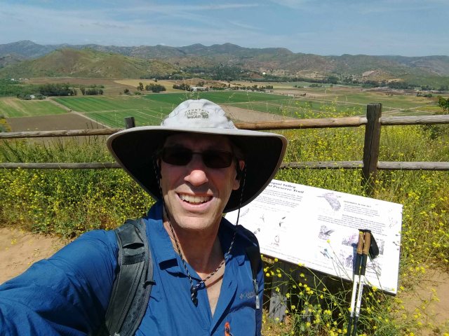
If you had to guess what the most difficult part of my day was going to be, taking a selfie probably would not have made your list. If you want to get ‘credit’ for completing the challenge, you need to send in a selfie from a designated spot. These were indicated on maps from the website, and for the most part, said maps were pretty accurate; but in my, albeit early morning and slightly sleep deprived, opinion, the spot on the website’s map didn’t quite match up to the actual place where the photos were taken. I spent more than a little time searching for the location which matched the photographs on the Challenge website. It didn’t help that I went right instead of left at the loop junction. It shouldn’t have mattered since I was hiking the entire loop, but if I had gone right, I would have seen the fallen tree and selfie location before making it to where it was drawn on the map. Enough complaining; I found the designated spot, took the selfie, and then finished the hike — one down and already well behind my planned schedule.

When I say ‘planned schedule,’ it wasn’t a schedule for doing all five hikes; I just wanted to finish a couple of hikes and bail in time to miss rush hour. But I wasn’t going to let a little (lot) of traffic keep me from checking out one more trail.
Whereas the Santa Ysabel Preserve was the longest trail in this year’s challenge, the Ramona Grasslands Preserve Trail was the shortest. It was after eleven when I headed out to take in the open space of the Ramona Grasslands Preserve. There were several people enjoying the footpaths, a few more than I saw at the Santa Ysabel Preserve (where I had the place to myself until I was nearly back to the car.) I was moving at a good pace, though not as fast as a couple of trail runners. It was an easy route, little gain, and I was back to my trusty Acura in a little over an hour. Ten miles completed.

After some water and snacks (I never took an actual lunch), I checked out the route to the Raptor Ridge Segment of the Coast to Crest Trail. It was only a 15-minute drive and along the route back towards the freeway. What the heck, I was feeling fine and a fifteen-mile day would be good for me. The Raptor Ridge Segment of the Coast to Crest Trail, as well as the Piedras Pintadas Trail, is on the outskirts between Escondido and Rancho Bernardo. This meant there might be more people on the trail, but it was midday and midweek, and I was the only car in the trailhead parking area for the Raptor Ridge portion of the trail. Indeed, I didn’t run into another hiker, only a number of courteous mountain bikers.
The trail is flat for the first one-and-a-half miles as it follows the San Dieguito River upstream. All the 400 feet of elevation gain comes at the end. One of the most unusual features of the trail, something I had never seen before, was a bike maintenance/repair stand along the path. Pump, tools, stand: pretty much everything you needed to get your bike in good enough shape to make it back to the trailhead.

I was on the trail during the warmest part of the day and was glad I didn’t skimp on bringing water. The views are nice from the selfie spot, but I didn’t stay long.
Back at the air-conditioned car, I weighed my options. If I left for home now, I would be sitting in heavy congestion for hours. The Piedras Pintadas Trail was only a handful of minutes away. This is where things got a little out of hand. If I did the Piedras Pintadas Trail, my total mileage for the day would be around nineteen, more than I had hiked in a day all year. And I would be left with only one segment to finish. Would I really want to drive back just to do a short hike?


A small sampling of the many wildflowers still in bloom
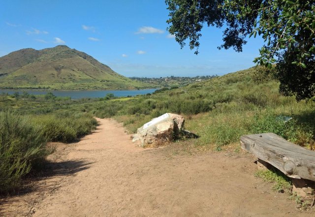
I was almost there, and really, what’s another four miles among friends. No need to get ahead of myself, just one step at a time. The Piedras Pintadas Trail was easily the most trafficked of the day’s paths. Thankfully, there was a nice breeze, and Lake Hodges, formed by a dam on the San Dieguito River, provided a scenic distraction for my tired muscles. A bench at the selfie location called out to me, and I enjoyed the illusion of wildness during a brief respite.
I went through the last of my water on the way back to the trailhead and stopped a gas station convenience store for more. While waiting in line, a bag of M&Ms with Peanuts serenaded me. To quote Oscar Wilde: “The only way to get rid of a temptation is to yield to it.” The sugar fix felt good, but the day was getting away from me.
I plugged in the location of the last trailhead into my phone and took off. Back in the day, we had a saying: “To err is human, but to really foul things up, you need a computer.” More than once I’ve seen the admonitions not to trust Google to get you there. This was one of those times: more accurately, several of those times as Google kept trying to route me through a private community.
The gate for the Santa Fe Valley Trail closes at 7:30 pm. It was almost 5:30 pm when I parked. Time to hurry; I was tired, but the M&Ms provided fuel to my nearly depleted energy reserves. Down the trail I went. The first ten or so minutes life was good, nothing to worry about. A coiled rattlesnake in the middle of the trail brought me to a full and complete stop. Neither one of us wanted anything to do with the other. Happily, Mr. Snake didn’t require any persuasion to take off into the bushes where I could no longer see it, which is not as comforting as one might think. Yes, I’m too big for the snake to eat, but I gave as wide a berth as possible to the spot where the snake disappeared. Adrenaline added to the sugar, I got a move on, while carefully scanning ahead for other serpents. (Trish, from the San Dieguito River Valley Conservancy, sent me a note the other day that “According to our herp [herpetologist] expert, if you see one snake in the area, there are 50 more within a few hundred feet!”)
The rest of the way was gratefully uneventful, and I made it to the last selfie location in short order, then back at my car, where I exited the gate with almost a half-hour to spare. About 23 miles, a couple of thousand feet of total elevation gain, and lots of commuting between trailheads were completed in under twelve hours. All that was left was to stop at the nearest Costco for gas, and pizza, before heading for home.
I can’t wait to see what’s in store for next year’s Coast-to-Crest Challenge.
For more information visit the San Dieguito River Valley Conservancy website: https://sdrvc.org/coast-to-crest-trail-challenge/

Thanks, Wayne, for all you did for our family the last few months. You did more than your share and my gratitude and appreciation just don’t seem to be enough. I’m glad you took a day off and had enough energy to make all five hikes. Amazing! Thanks for you inspiring story. I enjoyed it and wished my body would still enable me to hike. Maybe I could do the shortest one…
LikeLike